Worldwide Webcams
- Central America/Mexico -
Central America is a subregion of North America. Its political boundaries are defined as bordering Mexico to the north, Colombia to the south, the Caribbean Sea to the east, and the Pacific Ocean to the west. Central America is usually defined as consisting of seven countries: Belize, Costa Rica, El Salvador, Guatemala, Honduras, Nicaragua, and Panama. The United Nations geoscheme for the Americas defines Central America as all states of mainland North America south of the United States, hence grouping Mexico as part of Central America for statistics purposes, but historically and politically Mexico is considered a part of North America. For now, since we only have a few cams from Mexico and a few more from Central America, we will have them share the same page. In time that might change and Mexico might receive its own separate page.
The official language in all Central American countries is Spanish, except in Belize, where the official language is English. The majority of the population is mestizo, with sizable Mayan and African descendent populations present, along with numerous other indigenous groups such as the Miskito people. The immigration of Arabs, Chinese, Europeans and others brought additional groups to the area.
Central America has over 70 active volcanoes, 41 which are located in El Salvador, and Guatemala.The volcano with the most activity is Santa María. Still experiencing frequent eruptions to this day, with the last one beginning in 2013. Of the many mountain ranges within Central America, the longest are the Sierra Madre de Chiapas, the Cordillera Isabelia and the Cordillera de Talamanca. At 4,220 meters (13,850 ft), Volcán Tajumulco is the highest peak in Central America.
- Central America Cams -

Miraflores Locks, Panama Canal, Panama
(This cam and the next
two are from
Canal De Panama)
Miraflores Locks is on the Pacific side of the Panama Canal.
Note: Sometimes, with these 3 Panama Canal webcams, you will not see an image, it has to do with how these cams update. Please wait about 10 seconds and reload page if/when this happens.
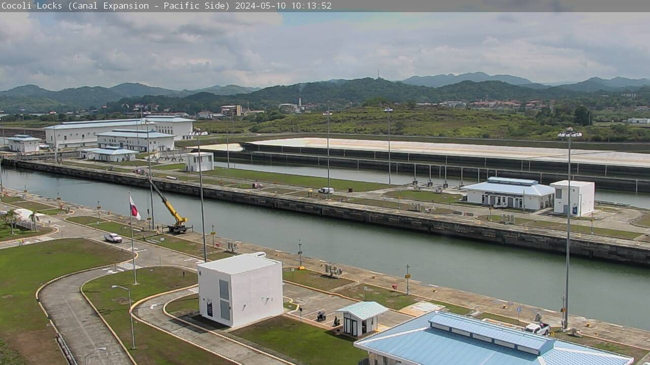
Cocoli Locks, Cerro Luisa, Panama Canal, Panama
Cocoli Locks is also on the Pacific side of the Panama Canal. This new lock opened in 2016.
The Panama Canal (Spanish: Canal de Panamá), a lock-type canal, is owned and administered by the Republic of Panama, that connects the Atlantic and Pacific oceans through the narrow Isthmus of Panama. The length of the Panama Canal from shoreline to shoreline is about 40 miles (65 km) and from deep water in the Atlantic (more specifically, the Caribbean Sea) to deep water in the Pacific, is about 51 miles (82 km). The canal, which was completed in August 1914, is one of the two most strategic artificial waterways in the world, with the other being the Suez Canal. Ships sailing between the east and west coasts of the United States, which otherwise would be obliged to round Cape Horn in South America, shorten their voyage by about 8,000 nautical miles (15,000 km) by using the canal. Savings of up to 3,500 nautical miles (6,500 km) are also made on voyages between one coast of North America and ports on the other side of South America. Ships sailing between Europe and East Asia or Australia can save as much as 2,000 nautical miles (3,700 km) by using the canal.
Locks at each end lift ships up to Gatun Lake, an artificial fresh water lake 85 feet/26 meters above sea level, created by damming up the Chagres River and Lake Alajuela to reduce the amount of excavation work required for the canal. Locks then lower the ships at the other end. An average of 52,000,000 US gallons/196,841,413 liters of fresh water is used in a single passing of a ship. Because of this, the canal is threatened by low water levels during droughts.
The two cams shown above, are on the Pacific side of the Panama Canal. Miraflores Locks, one of the original locks, has 2 chambers, with a +16.5 m (54 ft); spillway and the newer Cocoli Locks has 3 chambers and 3 water saving basins each.

Agua Clara Locks, Panama Canal, Panama
This last cam shows the Agua Clara Locks, which is on the Atlantic Ocean side of the canal. They are the newest of the locks, opened in 2016. They have 3 chambers, with 3 water saving basins each.
The full story about the Panama Canal is long and very interesting, but the main purpose of our site is to show off webcams, with just a bit of an explanation given. We suggest that you do a web search for more info on this very interesting story on how it came about and was built and other interesting facts about this wonder of the world.
- Guatemala -
Guatemala, officially the Republic of Guatemala, is a Central American country south of Mexico. It is home to volcanoes, rainforests and ancient Mayan sites. The capital, Guatemala City, features the stately National Palace of Culture and the National Museum of Archaeology and Ethnology. Antigua, west of the capital, contains preserved Spanish colonial buildings.
Guatemala is bordered to the north and west by Mexico, to the northeast by Belize, to the east by Honduras, and to the southeast by El Salvador. It is hydrologically bordered to the south by the Pacific Ocean and to the northeast by the Gulf of Honduras. Guatemala is mountainous with small patches of desert and sand dunes, all hilly valleys, except for the south coast and the vast northern lowlands of Petén. Two mountain chains enter Guatemala from west to east, dividing Guatemala into three major regions: the highlands, where the mountains are located; the Pacific coast, south of the mountains and the Petén region, north of the mountains. All of its major cities are located in the highlands and Pacific coast regions. Volcán Tajumulco, at 4,220 meters (13,850 feet), is the highest point in Guatemala and in all of the Central American countries.
Guatemala has a population of 17,608,483 (2021 est.), and had the fastest population growth in the Western Hemisphere during the 20th century. The country has a young population, with the estimated median age being 20 years old, 19.4 for males and 20.7 years for females. It is demographically one of the youngest countries in the Western Hemisphere, comparable to most of central Africa and Iraq. The proportion of the population below the age of 15 in 2010 was 41.5%, 54.1% were aged between 15 and 65 years of age, and only 4.4% were aged 65 years or older.
Guatemala experiences a tropical climate with distinct dry and rainy seasons. The dry season runs from November to April, while the rainy season spans from May to October. Temperatures vary significantly based on altitude; coastal areas are hot year-round, while highlands are cooler, with the lowlands and coastal areas being hot and humid with average annual temperatures of around 27°C (80°F). Temperatures can reach 38°C (100°F) during March and April. In the highlands, cooler temperatures prevail, with average temperatures between 16°C and 21°C (60°F and 70°F) in mountain valleys like Quetzaltenango, Guatemala City, and Antigua. For the highest mountains, temperatures can drop down to 0°C (32°F). Looking at the hottest and coldest ever temperatures ever reached in Guatemala, the town of Huehuetenango holds both of the country's records for these, a very rare event for any country, anywhere. Situated 269 kilometers/167 miles from Guatemala City, at a elevation of 1,901 meters/6,237 feet, the hottest temperature ever seen in Guatemala was set here on May 12, 1998 when the thermometer reached 40°C (or 103°F). Yet Huehuetenango also seen the coldest temperature ever experienced in Guatemala, when it dropped down to -4°C (25°F) on February 2, 1983.

Guatemala City, Guatemal
(from
Aeroclub de Guatemala)
Guatemala City is the capital of Guatemala and the largest city in Central America. It is the political, social, cultural, and economic center of Guatemala. The city is located in a mountain valley called Valle de la Ermita (English: Hermitage Valley) in the south-central part of the country. The present city was founded by the Spanish after their colonial capital, now called Antigua Guatemala, was destroyed by the devastating 1773 Santa Marta earthquake and its aftershocks.
The city's metropolitan area has recently grown very rapidly, and its population in the capital city in 2023 was 1,221,739, with a density of 5,552/km2 (14,380/sq. mi). Its urban population in '23 was 3,014,000. The city's elevation sits at 1,500 m (4,900 ft). Despite its location in the tropics, Guatemala City has a monsoon humid subtropical climate due to its relatively high altitude which moderate the average temperatures. It is generally very warm, almost springlike, throughout the course of the year. The highest temperature ever reached took place twice, once in April and once in May when both times it reached 33.9°C (or 93.0°F). It has never gotten colder than 6.0°C (or 42.8°F) when that was reached one day in January (exact date not given). The city does see a lot of rain, with 125 rainly days a year, averaging 1,274.8 mm (50.2 inches) per year.
- Mexico -
Juarez
Lincoln International Bridge (Mexico side), Nuevo Laredo, Mexico
(From
City of Laredo)
The Juárez–Lincoln International Bridge is one of four vehicular international bridges located in the cities of Laredo, Texas, and Nuevo Laredo, Tamaulipas, that connect the United States and Mexico over the Rio Grande (Río Bravo) River. It is owned and operated by City of Laredo and the Secretaria de Comunicaciones y Transportes (Mexico's federal Secretariat of Communication and Transportation). The Juarez-Lincoln International Bridge was named in honor of the Mexican President Benito Juárez and U.S. President Abraham Lincoln. It was built in 1976 to alleviate traffic on the Gateway to the Americas International Bridge and to accommodate the fast-growing cities of Laredo and Nuevo Laredo. The bridge has eight lanes and is 1,008 feet (307 meters) long and 72 feet (22 meters) wide. The international bridge is for buses and non-commercial traffic only.
Daily traffic on the bridge is: Non-commercial vehicles: 13,133; commercial vehicles (buses): 103. Toll for non-commercial vehicles as of 2024 is $1.75/axle (southbound) and 30 pesos (northbound); buses $4.75/axle (southbound and 65 pesos (northbound).
Acapulco, Guerrero Live, Panoramic View of Santa Lucía Bay, Mexico
(from Webcams Mexico)
Acapulco (/ˌækəˈpʊlkoʊ/ AK-ə-PUUL-koh, US also /ˌɑːk-/ AHK-; Nahuatl languages: Acapolco), is Mexico's largest beach and balneario resort city. This resort town sits on Mexico's Pacific coast, and it's also a major seaport. Located in the state of Guerrero on the Pacific Coast of Mexico, it is 380 kilometers (240 miles) south of Mexico City. The city of Acapulco is the largest in the state, larger than the state capital Chilpancingo.
Set on a large bay backed by high-rises and the Sierra Madre del Sur mountains, it was made famous by the jet set in the 1950s and ’60s, and today is still known for its high-energy nightlife, beaches and golf. From its iconic La Quebrada cliff, professional divers plunge 40 meters (131.2 feet) into a small ocean cove every day and night - authentic Mexican charm that sets it apart.
Acapulco features a tropical wet and dry climate; hot with distinct wet and dry seasons. Hottest temperature ever seen here was set in January: 39.5°C (103.1°F), while the coolest ever temp was 16.0°C (60.8°F) reached twice, once in April and then once again in October. The 2 hottest months on average are July and August while its driest times runs from mid November thru May, while June thru October sees a good amount of rainfall.
Popocatépetl Volcanoe, Altzomoni View, Mexico
(from webcamsdemexico.com)
This webcam comes from the Holiday Inn Puebla Hotel. Barranca Nexpayantla and the mighty Crater Popocatépetl. Renowned as the second-highest peak in Mexico, it lies at 5,393 m (17,694 ft.), in the eastern half of the Trans-Mexican Volcanic Belt (the highest peak in Mexico is Citlaltépetl [Pico de Orizaba] at 5,636 m [18,491 ft.]). Popocatépetl is 70 km (43 mi) southeast of Mexico City, from where it can be seen regularly, depending on weather conditions.
Until recently, the volcano was one of three tall peaks in Mexico to contain glaciers. By the 1990s, the glaciers were greatly decreased in size due to warmer temperatures caused by man-made climate change. Sadly, by early 2001, Popocatépetl's glaciers were totally gone.
Popocatepetl stands as a symbol of nature's grandeur and unpredictability, regularly showcasing plumes of ash and intermittent eruptions.
Iztaccíhuatl or Ixtaccíhuatl is a 5,230 m (17,160 ft) dormant volcanic mountain in Mexico located on the border between the State of Mexico and Puebla within Izta-Popo Zoquiapan National Park. It is the nation's third highest, after Pico de Orizaba and Popocatépet. The name "Iztaccíhuatl" is Nahuatl for "White (like salt) woman",reflecting the four individual snow-capped peaks which depict the head, chest, knees and feet of a sleeping female when seen from east or west.
Iztaccíhuatl's last eruption took place in 1868.
- Panama Canal Map - -
Bridge
Map -
| Worldwide Webcams Home Page | Colorado Web Cams | New York Webcams | New York City Webcam | Long Island Cams |